 |


 |
 |
 |
|
|
S.P. Publishing Group Co., Ltd.
11/1 Soi 3 Bamrungburi Rd., T. Prasingh,
A. Muang., Chiang Mai 50200
Tel. 053 - 814 455-6 Fax. 053 - 814 457
E-mail: guidelin@loxinfo.co.th
|
|
 |
|
 |
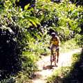
Mountain-biking up Steep Doi Pui Text: John Cadet
Images: Jerry Alexaner & Oliver Hargreave
Although pedaling placidly through the numerous country lanes outside of town in the Chiang Mai valley is always agreeable, it's sometimes interesting to ratchet up the excitement and exchange level paths through rice fields for steep jungle trails in dense forest cover. After all, Chiang Mai has mountains, and they are called mountain bikes! One need not travel far to pursue this activity; the Doi Suthep National Park just west of the city offers a superb network of trails serious enough to challenge the most enthusiastic rider. Modicums of physical fitness, as well as logistical preparations are required to keep the adventure a safe and amusing one. Most rides of this type are around 30-40 kilometers with both climbing and descents involved. When the rains have stopped, the foliage is verdant and the air clean and crisp, so come along on a ride we took recently, and then decide if you're ready to take your own trip.
Steep trails
Our rendezvous point is the base of Doi Suthep near the Chiang Mai zoo. Friends have ridden in from various points of the city in the quiet of an early Sunday morning, one of the few times urban cycling in Chiang Mai is acceptable. Everyone is carrying a small daypack or bicycle panniers, which hold a supply of food, water, a heavy shirt against the chill, a spare inner tube and mini-pump. Helmets, if not a sunhat, cycling gloves, sunglasses, cameras, sunscreen, a small tool kit, all are a matter of personal preference, but the goal is to be comfortable while keeping the load as light as possible. While the 12-kilometer climb up Doi Suthep is not difficult (a good time for that is on the night of the full moon during the hot season, but that's another story), we're anxious to get off the beaten track and into the jungle, so we hire a waiting songtaew (the ubiquitous red minibus which passes for public transport in Chiang Mai) to carry us up to the Phu Ping Palace. Three bicycles and three riders squeeze comfortably into the back of the songtaew; if needed a fourth can join the driver in the cab.
The road forks soon and we turn right to Doi Pui. Turning left leads to the village of Baan Doi Pui, a Hmong village heavily visited by tourists. It's possible to cycle down the East of the mountain via that route, but today we are going for a simpler loop taking us down the Western face. The rains have only just ended and the side getting maximum exposure to the sun is least likely to turn into a mudslide. Bearing right, we climb another kilometer and take a quick break at a viewpoint overlooking the Hmong village. Far below roosters crow and looking north we can count dozens of ridgelines. A heated discussion emerges as to whether Doi Chiang Dao is visible in the distance. Various local experts postulate; no one really knows. A final push and we are through the climb and descend into San Ku, a mysterious ruined chedi still revered by local worshippers. An official plaque placed by the Fine Arts Department claims that the chedi was built in the 13th century. No one really knows.
Now the road winds gradually down, snaking though immense teak trees. All thoughts of the pain of the earlier climb are forgotten as we glide through the cool forest. Wildflowers line the road, at this altitude blooming much sooner than in the city below. Rolling through the switchback bends, the occasional whoop of an excited rider is the only sound. A few kilometers further, we arrive at a kiosk and sign announcing the summit (1670 meters) of Doi Pui.
Coffee Plantation & Flower Garden
The summit is currently not open to the public, and in any case our route leads to the right and marks the end of paved road. The descent steepens and we proceed carefully to avoid patches of loose gravel and deep ruts that can send the unwitting rider skidding into a case of "road rash". An experimental tree farm, a coffee plantation, lines of temperate weather fruit trees in bloom, all remind us that this natural refuge provides many uses aside from the pleasure it now gives us.
A couple of kilometers beyond the Doi Pui summit gate, we leave the still unpaved main road and detour to the right into Baan Chiang Khian, (inexplicably signposted "Sri Nehru School") a village of the White Hmong hill tribe. It's a good place to stock up on cold drinks. During a ride like this in hot weather, two liters of water is a reasonable intake. Back to the main road, and now a seriously steep descent commences. Consider lowering both the seat (to lower your center of gravity), and possibly lowering tire pressure (for better traction). About five kilometers below the village turnoff, the road forks and we take the right, which is sign posted to Huay Thung Thao. Going left leads eventually to the Queen Sirikit Botanical Garden in the Mae Sa valley, but only after a grueling climb and lengthy descent.
We continue our descent, now the strength of our upper bodies and hands tested, keeping balance and the correct pressure on the brake levers. The first sign of human existence is a lychee orchard and terraced rice fields in a lovely hidden valley. We feel the heat as we return to the lowlands and the massive first growth forest dissipates; now we ride through scrub and a sandy trail. Now is the time to pause and look back at the mountain behind us During the last 12 kilometers we have descended over 1000 meters, and the mountain looms above us. Next, we see the blue waters of Huay Thung Thao, a local reservoir and nature reserve on the horizon and below us.
From the Huay Thung Thao reservoir, it's an easy ride on the flats next to the canal road back to the base of Doi Suthep from where we initially climbed into the songtaew some hours earlier. From where we commenced our climb at the Phu Ping Palace, my odometer shows a mere 33 kilometers, but the varied terrain and superb scenery we've enjoyed has made for a full day's adventure, all within range of home. All in all, a great way to spend a day in Chiang Mai.
NOTE: This ride should not be undertaken alone or without the necessary tools to repair a flat tire or broken chain. There are many small trails leaving the main dirt road down the back of Doi Pui to Huay Thung Thao; stay on the main track. Watch out for motorcycles and pick up trucks. Use prudence on the descents. The line between an adventure and an ordeal is a thin one. Still fancy mountain-biking yourself? Try Velocity Bikes (tel: 053 410665) 150 baht per day. Alternatively, Contact Travel (tel: 053 277178) also provide transportation to the start and at the end of the ride, with a guide and lunch - 1500 baht per person.
 (Text � John Cadet 2005) (Text � John Cadet 2005)
|